CONTACT US!

This album of travel inspiration has been brought to you by Melanie @ Tough Love Travel!
Talk to Melanie at (609) 923-0304 or melanie@toughlovetravel.com.
Or visit her at www.ToughLoveTravel.com for "fun adventure to get your out of your box".

Friday, June 28, 2013

The Crying Rock: how my family survived the Grand Canyon!

The summer of '01, my family drove 2300 miles from our home in NJ to take 15,000 footsteps to reach the floor of the deepest canyon in our nation.  But that was only the beginning of our story...


The waking sky had only streaks of yellow and orange when the 5 of us set out to hike to the bottom of the Grand Canyon. 
It was a clear July dawn as we strode off the rim -- fortified by the dining hall's scrambled eggs, stocked with bottles of water and salty snacks (no "death by water intoxication" for us!), sheltered in bandanas and caps, and informed by the Grand Canyon ranger safety video. 
As the waking sun lowered the shadows down the strirated canyon walls, our rocky path grew clearer and the broad canyon vista before us gained depth and color.  The canyon's walls-  layers of rust, black, and mustard - represented centuries, piled atop each other, and as we hiked down through time, it felt surreal, magical.  It felt like entering a chasm.


We descended... snacked... hiked... posed for photos.  

The random stark pine tree stood out bright and lively against the desiccated landscape, but gave no shelter from the fiery sun,  now beaming down on us from the deep blue sky overhead.
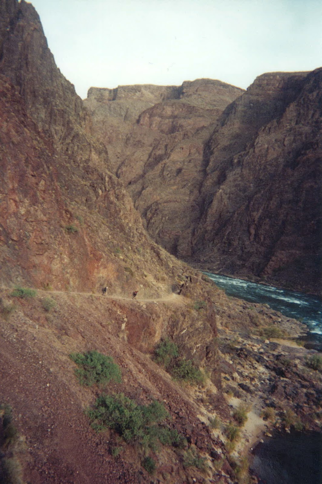
Our boots slowly turned dusty gray from the parched trail below us. 
Yet we followed the lone trail, deeper and deeper, into the crevasse.

We crossed over a stream or two, picking our steps from one flat stone to another, and paused to delight over the tinkle of water that flowed through such a stark land.  

By Indian Garden (about mile 4), we were thankful to find shade and water spigets.   And as the July heat intensified, we remembered the popular canyon slogan -- "Hike Wet".  So we started to lie down -- head and all -- in each creek we crossed.   The thermometer had reached three digits. 


After about 6 hours and 7 miles, WE MADE IT! .... or so we thought. 
The trail ended, on a cliff edge, below which the Colorado River roared.
With water bottles low and our spirits the same,  our overheated bodies peered longingly at the unreachable water some 30' below -- a painful contrast of 50* rapids in 115* heat.
Somehow, the GC safety video had failed to include this detail. 

With toes at rim, we surveyed our options.  There was really only one. 
The trail took a sharp right-hand turn to follow the rolling river banks, with not a speck of shade in sight. The campground bridge MUST be in that direction. 

So off we trudged. 
But the heat had gotten unbearable, and our resolve was buckling. 

When we thought it could get no worse, the path turned to deep sand -- reflecting the intense heat back on our cheeks, sucking in our burning boots. 

At each twist of the trail, we searched the foreground for some sign of the bridge, and were just too overheated to take the disappointment of endless empty desert before us.

Curves and rises.   Over and over. 
I panted hot breath out of my mouth.  
I sipped  water, like warm bland soup, from my bottle.   
I saw my young crew, staring down at their scorched boots, pushing through the dun sand. 
We were getting dangerously worn down. 

Then around a bend, a giant rock appeared, overhanging the trail.  
Without any discussion, we all 5 scurried to the shade under the rock, and took a collective sigh.

I looked around our circle of red anxious faces.
My 15-year-old outdoorsman was stoic, realizing the severity of our situation. 
My moody 13-year-old was fuming, wondering why he wasn't in music camp in the  Canadian woods right now instead of at the bottom of this inferno.
My 11-year-old, Doug, looked to me, his fearless leader, wondering what I was going to do. 

And that's when I saw the eyes of my 9-year-old, welling up. 
Little Tom, overwhelmed, was cracking. 

My mind sped -- what to say?   how to encourage?  were we even safe?  
I felt genuine fear for the first time, and could sense my own eyes stinging with tears.

Then, magically, Doug stirred. 
He stepped up to Tom and put his arm firmly around his brother's shoulder.   In his best big-brother voice,  with barely a quaver, Doug said, 
"C'mon Tom... there's the bridge.  We'll do it together". 

And with that,  they stepped off. 

The other 3 of us were so stunned that we stepped too.  
Sucking up our own hidden tears, we plowed onward, and before we knew it, the bridge indeed got larger, closer.  The deep sand pulled less.   And we defied the heat -- now well over 120*  around noon -- as we single-mindedly and with a new energy, marched to the bridge,  over the wild rapids, and  to a protective ranger and our campground for the night. 

NOW we HAD made it!
Just feet over the bridge, we tore our packs off and almost ran for the Bright Angel Creek, a small bubbling tributary.  We splashed down, boots and all -- and you could hear a collective "ahhhhhhhhhh".   We smiled -- and even laughed at loud -- at our surviving! 

We spent most of that afternoon in that creek, with short spurts to set up camp or grab food from our packs. 


That evening, we joined the ranger program for a little geology lesson.  
The board at the entrance to the program said:

Take Caution. 
Temperature today: 
137* 

Thank goodness -- we had been saved by the Crying Rock, and a brave 11-year-old boy. 

This blog is dedicated to my 4 sons who, with blind faith and bottomless love (and not much choice, to tell you the truth),  followed  me on our annual 6-week roadtrips all around the United States, each summer of their childhood.   

Friday, June 14, 2013

Kayaking the Sea Caves: family lore on Santa Cruz

Where is Santa Cruz?   It's one of  the many islands of Channel Islands National Park, off the southern coast of California. 

Very unlike Catalina,  Santa Cruz is completely rustic.  That means that you have to bring your water and food -- and kayak guides! -- with you when you go there.  But it's worth it!

Here's the story of how my family bonded in the sea caves of Santa Cruz, in the summer of 2002...

We had arrived on Santa Cruz the day before, via national park ferry from Ventura.   After 20-miles on the ferry, we then had to cart all our gear for this rustic adventure 1/2-mile inland to our campsite in a grove of giant eucalyptus trees (see below for fun Santa Cruz fact!)  

We returned to the beach to snorkel -- normal creatures, abnormally crystal water! --  and after a camp dinner of noodles and chicken,  hiked over this scrubby, barren, Santa Cruz landscape to a western cliff, to watch sunset.

"Island Packers" met us on the beach the next morning.  Outfitted with helmet, vests, and paddles, in our sit-upon kayaks,  our guide led us out across the glassy green water of Santa Cruz' Prisoner's Harbor.


Santa Cruz' shoreline is riddled with hundreds of seacaves.  One unforgettable cave held the Green Room:  you kayak into this dark cave mouth and through a narrow, dark tunnel.  Then a room

suddenly opens up with sunlight streaming down into the sea from an opening overhead, the reflection creating a vivid green glow to the entire "room".   I think this was in Sea Stack Cave!

Later we paddled west, around the point, to Surging T Cave and Little Blowhole Cave.  The guide had to time our entry by the waves, since only between sets could you paddle through the opening without the surge bumping you up on the cave ceiling.

I would NOT recommend this outing without a guide who's not only a kayak expert, but who also has intimate knowledge of these caves.

One cave that we didn't make it to is Painted Cave, one of the largest and deepest sea caves in the world.  It's found on the northwest coastline of Santa Cruz. Named because of its colorful rock types, lichens, and algae, Painted Cave is nearly a quarter mile long and 100 feet wide, with an entrance ceiling of 160 feet and a waterfall over the entrance in the spring.

Other things to do on Santa Cruz?
There are pristine tide pools along its 77-mile craggy coastline,
picnic tables at Scorpion Anchorage, 
guided interpretative hikes at Prisoner's Cove,
and boundless independent hiking -- from flat signed trails to rugged mountainous paths through the Montana area --  anywhere on the eastern 1/2 of Santa Cruz owned by the national park.   Here's a full map!
Another funny tidbit about Santa Cruz?   
The eucalyptus trees were imported here from South America where their hard wood was highly valued for building and shipping.   However, that's SOUTH of the equator and, on Santa Cruz in the northern hemisphere, the fibers of the tree grew and twisted in the opposite direction (think toilet flushing or bats circling out of a cave...), making the wood worthless!  Still, the shade of their huge umbrella limbs was divine on this arid island and their scent was magical-- you felt like you were sleeping in a spa!


NOTE FROM MELANIE at  TOUGH LOVE TRAVEL...
Santa Cruz in the Channel Islands remains one of my most unforgettable adventures.  
I'd love to set you up on your own summer adventure!  
I offer free, 20-minute calls to talk it over!  

Tuesday, June 11, 2013

Quick-n-easy summer memory on Block Island!

Melanie @ Tough Love Travel is an expert travel designer!  Mine her brain for your OWN get-aways and don't miss out - SUMMER IS NOT ENDLESS!
Call her now to get started:  (609) 923-0304!

What's special about Block Island?
It's a snap to get to Block Island from the Northeast or New England, yet - once there -- you're in a  different world -- an 11-square-mile summer playground of bikes and sailing, lobster and clambakes,  nature and architecture that's described as "no-frills Block Island Vernacular".

If you want a quick getaway for your family,  or you want a couple of bonding days with your teenager, or if you 're looking for some fun in the sun with your sweetheart,  Block Island more than fills the bill!


How do you get to Block Island?
Get to New London, CT by either car on 95N or via Amtrak/Acela, then ride the Jessica W, a 500-passenger catamaran, for just over 1 hour to Old Harbor on Block Island!

How to get around Block Island?
When I got off the ferry, I walked 50 yards to the first bike rental shop, Island Moped and Bike Rentals  and got myself 2 wheels.  As long as you're not pregnant and in reasonable physical shape, biking is the way to get around!

You'll find that Block Island is saturated with bike paths so that, in addition to biking on the paved  though quiet roads, there's a dense system of dirt roads and bike paths to explore!

If you don't bike, your options include island taxi or even mopeds (if you have good medical insurance).
If  this is the case, I'd recommend that you lodge right in Old Harbor to make transportation easier, since many of Block Island's restaurants and shops are right in town.

Best hiking on Block Island?


On the south shore of Block Island, you'll find the 150'-tall Mohegan Bluffs.  Named after a 15th century battle, these cliffs can also pose a different kind of battle for beachgoers who spurn the 144-step staircase (see left) and try to shimmy down the wild cliffs!


Also on Block Island are specific trails, like this Clay Head Nature Trail, which leads you through migratory songbird habitats for 1/3 mile to the northeastern beach.  Look for a sign like this:


My favorite beach hike is out to the North Point Lighthouse, this spit of sand reaching up into the Atlantic:
But the real bragging rights come from hiking the length of the 25-mile Greenway Walking Trail!

Eating on Block Island?
From lobster sliders right on the dock, to lobster dinners on the porch of the National Hotel -- you're in for a crustacean-lovers vacation!

In addition to getting my vote for "Island with  MOST scenic porches for Cocktail Hour!",  there are also fun eateries like this place, the Oar!

A "Shore Dinner" is a big deal on Block Island.  It's basically  the day's catch of lobster, clams, and mussels, served with potatoes and corn.  You can order one for your group of 10, or join the Lion's Club in September for their Annual Lobster Bake.

Where to stay on Block Island?
As a first-timer, I stayed at the National Hotel (see top photo in this blog), a vintage victorian mansion with oversized wrap around porch, just steps from the ferry dock.   It's on the National Register of Historic Places and is a real classic!

For a more island-y feel, I later  tried the Narragansett Inn.  It's about 1/2-mile from the ferry dock, on a knoll overlooking Great Salt Pond (Block Island's ground zero for all things sailing).   They have a large porch where you can enjoy your meals, and they encourage guests  to drag wooden chairs out on to their lawn for sunset.   Check out the view:

Or  ready for something really different?  Try a sleepaboard  sailboat, out in the mooring field (see Sophia, below).

Which leads me to... the sailing scene on Block Island?
There's a  well-organized sailing school in the Salt Pond called  Block Island Marine Institute, and everyone from 8 to 80 year olds can learn!

You can also go on sunset sails on the Sophia!

Tough Love Travel's best guide on Block Island?
It's Corrie, who owns a kayaking outfit called Pond & Beyond.   My favorite?  a sunrise kayak through Block Island's New Harbor, and out beyond the point.  Check out her website!

Need summer vacation inspiration?   
I can inspire you!  Grab a free 20-minute phone call right now!

Friday, June 7, 2013

Sleeping in a lighthouse in San Francisco Bay!

From Alcatraz, the notoriously punishing prison in San Francisco Bay, inmates stand in the cafeteria where even silverware is withheld, and feel absolute confinement and longing -- yet, they peer through the barred windows out to the mouth of the bay and to the endless freedom beyond.   This contrast, they say, is the ultimate soul crusher at Alcatraz.

There are better ways to spend the night in San Francisco Bay!
Did you know that you can sleep in a lighthouse, out in the middle of the water?

WHERE'S THE SAN FRANCISCO BAY LIGHTHOUSE ?

Overnights at East Brother Light Station are  an adventure you'll not soon forget!
It all starts with a 30-minute boat launch out to an island in the bay, where you're greeted with a champagne  reception.  


WHAT TO DO AT SAN FRANCISCO BAY LIGHTHOUSE?

Spend the evening learning the history of this light, which dates back to 1874, or watch a foghorn demonstration straight from the "old days".  Walk up to the lantern room, and even out onto the widow's walk for a 360* view of the bay at sunset!  Imagine...
You won't be alone out there!  At the East Brother Victorian B&B, there're 4 period-decorated rooms, holding up to 8 guests, plus caretakers who will serve you the island specialty -- Lighthouse French Toast Souffle -- the next morning.

COST OF THE SAN FRANCISCO BAY LIGHTHOUSE?

An overnight  in the middle of San Francisco Bay will cost you somewhere between $295-$415.
This includes your boat ride from Point San Pablo, your reception and overnight, your 4-course dinner (either in the lighthouse or on a nearby island!), and your breakfast, too.

ANY MORE IDEAS FOR SAN FRANCISCO BAY AREA?

After your one-of-a-kind overnight in San Francisco Bay, here are some of my favorite things to do in  the city:


*  Go on a staircase hike!  Meet my local  gal who'll take you on usual tour  (aka  workout) of her city, via the amazing mosaic  tiled staircases!


*Go on a back-kitchen foodie walk through the restaurants of  the Mission with another of my favorite guides!


*Hunt for  blackberries on the wild grounds  of the Presidio (then have dinner in the old Officer's Quarters).


*Ride the ferry up to Napa's 
wine country for a "sensory seminar" on wines (what's a sensory seminar?  Call me at 609-923-0304 to hear more on this specialty excursion!)


*Go on an oyster crawl, starting at the storied Anchor Oyster Bar!


Want help with this (or some other) summer  vacation plan?
Grab a free phone call with Melanie,  the most creative and  exciting  travel designer and owner of Tough Love Travel. 
Here's the link... click it now!